

Santa Barbara Cell
 he first of the Southern California Bight cells to develop sand beaches, the Santa Barbara cell extends 154 km from Point Conception to the Mugu Submarine Canyon. All of this coastline - the only east-west trending coast in California - lies in the wave shadow of Point Conception and is protected from northwest swell.
|
|
Animation created by The Educational Multimedia Visualization Center of the Dept. Geological Sciences, U.C.S.B; Tanya Atwater, Director.
The Santa Ynez Mountains drop steeply to the coast, and the many small watersheds deliver high sediment yields directly to the shoreline. Formed by the collision of the Pacific and North American plates 20 million years ago, a block containing the Transverse Ranges and Channel Islands was torn away from the San Diego coast, pushed north, and rotated into this east-west orientation. The folded and faulted sedimentary formations that resulted from this collision yield copious amounts of sand during storms.
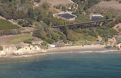
Image copyright © 2002-2004 Kenneth Adelman, California Coastal Records Project, www.californiacoastline.org
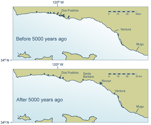
Sand beaches built in many of the small drainages by 6,000 years ago, but they were disrupted or lost after 5,000 years ago. Interestingly, sand beach habitats developed on the eastern Santa Barbara coast after 4,000 years ago.
Why did sand beaches appear, disappear, and reappear downcoast during these seven millennia? There is a strong correlation with El Niño and La Niña wave climates.
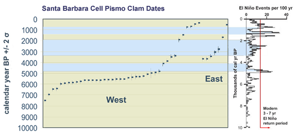
The moderate to strong El Niño events recorded at Laguna Pallcacocha in Ecuador should have caused storms and floods on the southern California coast as well. Frequent and strong El Niño storms starting around 5,000 years ago would have sent high waves directly down the Santa Barbara Channel. During westerly storm events, sand erodes from the western beaches and is transported to the east. Even though sediment runoff from the Santa Ynez Mountains also increases during El Niños, the higher wave energy drives the sand downcoast or into deep water. The western beaches apparently were lost after 5,000 years ago, a few rebuilt during the La Niña window 4-3,000 years ago, and disappeared again with the intense El Niño cycles around 1,000 years ago.
In the past 30 years, El Niños recurred about every 2-7 years although not all of them were moderate to strong events. The paleoclimate record from Ecuador indicates at least three much more energetic El Niño-dominated periods occurred in the past 5,000 years. In the future, if cycles of strong El Niño climate return, particularly if they are coupled with more rapid rates of sea level rise, the beaches of the western Santa Barbara cell likely will be lost again.
©2002-2004 by the Regents of the University of California and the Kavli Institute.
All rights reserved.
Last modifed Tuesday August 30, 2005