

Oceanside littoral cell
 f the five major littoral cells in the Southern California Bight, the Oceanside cell represents the simplest set of conditions: slow steady tectonic uplift relative to sea level rise, north/south trending coastline, narrow shelf, no major headlands.
TBA.
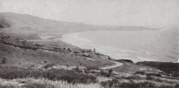
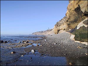
The cell extends from Dana Point in the north to La Jolla in the south, a distance of 84 km (52 mi). It includes the most studied coastal segments in southern California. For much of its length, semi-continuous sand or cobble beaches are backed by wave-cut sea cliffs. Eleven streams supply sediment to the coast, and six tidal lagoons still persist where the stream valleys reach the coast. There are two major sinks, Oceanside Harbor (periodically bypassed by dredging) and La Jolla Submarine Canyon.
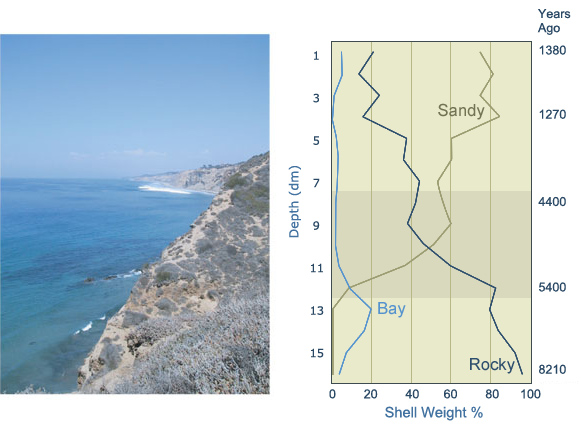
Early inhabitants of the San Diego coast were drawn to the lagoons where they collected scallops and clams, fished, hunted, and gathered plant foods. At the downdrift end of the cell in La Jolla, archaeological sites on the sea cliffs give us a picture of what the open coast looked like over the past 9,000 years. Deposits older than 7,000 years contain abundant shells from mussels and other attached growing mollusks that thrive on a rocky coast.
An especially well-dated site on the cliffs at Scripps Institution of Oceanography shows the important transition from rocky intertidal habitats to sand beaches occurred around 5,000 years ago. The oldest radiocarbon dates in the La Jolla sites for the Pismo clam are about 5,000 years as well.
The accretion of sand beaches in the Oceanside cell follows the long, dry, La Niña climate period 8-5,000 years ago. Very little sediment was delivered to the coast during that time. With the strengthening of ENSO cycles after 5,000 years ago, floods periodically brought large quantities of sediment to the coast. The relatively wide coastal plain and numerous lagoons north of La Jolla acted as sediment traps. The sand that did reach the coast was rapidly swept south to the submarine canyon sink at La Jolla by prevailing waves from the northwest. The relatively steep shelf with outcrops of resistant formations was slow to erode into a platform suitable for beach accretion. Consequently, sand beaches appear to have built in the Oceanside cell approximately 1,000 years after sea level rise had slowed.
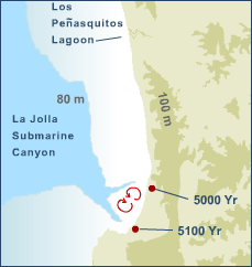
The unique configuration of the two submarine canyon heads at La Jolla set up the conditions necessary for sand beaches to form. Wave refraction over the two branches of the La Jolla Submarine Canyon system forms a bifoliate circulation pattern that traps sand between the canyon heads. With the flux of sediment generated by the strong El Niños ca. 5,000 years ago, much of which could bypass the northern branch of the submarine canyon at a sea level less that 5 m below present level, sand beaches began to build on the intercanyon shelf. For this reason, we find the 5,000-year-old Pismo clam dates at sites near the intercanyon sand beach.
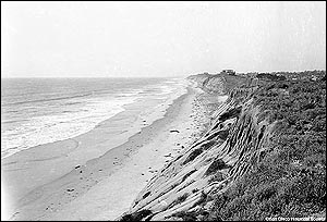
The other 83 km of high energy coastline north of La Jolla probably had transient beach deposits by this time, but without large headlands to retain sand or shelter beaches in their lee, it is unlikely that perennial beaches could form. Even today, severe winter storms erode the northern beaches to their cobble and bedrock platforms.
Photographer - Pat Masters, image used with permission.
Add to this scenario the predicted sea level rise of 50 cm by the end of the century, and it is likely that the northern beaches will be drowned and lost until the sea cliff retreats and widens the platform. That possibility is limited by the increased armoring of the coast with seawalls. Without sufficient natural sand supply, beach nourishment will be required in ever increasing quantities due to sea level rise submerging the platform.
©2002-2004 by the Regents of the University of California and the Kavli Institute.
All rights reserved.
Last modifed Tuesday August 30, 2005