

Sea Level
 uring the past million years, the earth's climate has fluctuated between glacial and interglacial conditions and caused large oscillations in sea level.
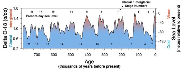
Delta O-18 curve. Adapted from Imbrie and others (1984).
Click here to see the reference.
Click here to learn more about the oxygen isotope record
Click here to learn more about climate proxy records
Stillstands are times of stable sea level when the ocean is neither rising nor falling rapidly. During stillstands, waves erode the coast and cut platforms in the rocky shelf. The platform provides a gently sloping base for the formation of sand beaches.
What sea level means for the beach
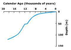
Sand beaches require a wide, gently sloping platform where sand is deposited and a beach can form. The present platform and sea cliff along the California coast were cut by wave action during the sea level stillstand of the last 6,000 years.
Sand beaches began to build in the Oceanside littoral cell about 5,000 years ago. Increased El Niño activity over the last 5,000 years brought enough sand to the coast to form beaches along the entire 84 km (~52 miles) of the cell.
©2002-2003 by the Regents of the University of California and the Kavli Institute.
All rights reserved.
Last modifed Tuesday, March 7, 2006