

Types of Coasts
 he beaches of southern California are usually backed by seacliffs. This feature of our coast is determined by its position on the earth's tectonic plates. There are three tectonic types of coasts:
- collision coasts are mountainous and occur on the leading edge of active plate margins where two plates are colliding or impinging on each other (west coasts of the Americas)
- trailing-edge coasts occur on the passive margin of continents and move with the plate (east coasts of the Americas)
- marginal sea coasts develop along the shores of seas enclosed by continents (Gulf of California and the Gulf of Mexico) and island arcs.
Differences between the west and east coasts of the U.S.
The west coast of the Americas has a narrow shelf and mountainous watersheds. The east coast has a wide shelf with coastal plains. Beaches form barrier islands that migrate landward in response to large storms. The Gulf of Mexico has a wide shelf and hilly coast whereas the Gulf of California has a narrow shelf and hilly to mountainous coast.
In addition, there are other types of coasts: coralline and mangrove (that depend on the growth of organisms) and arctic coasts (formed at high latitudes by ice push).
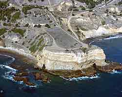
Top - Palos Verdes, California: Seacliffs are common in southern California. The Portuguese Bend area of Palos Verdes Peninsula remains undeveloped because the area poses natural landslide hazards.
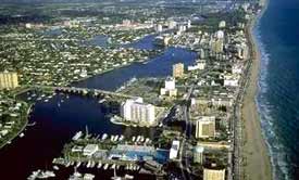
Bottom - Miami, Florida: Highrises fill the barrier island at Miami Beach, Florida. Narrow linear barrier islands rim much of the east coast of the U.S, paralleled by narrow linear lagoons on the landward side.
The Southern California Bight has an unusually wide borderland consisting of basins and narrow shelves. It is broken into many blocks by nearly vertical fault planes. Uplifted blocks created the offshore islands of Santa Catalina, San Clemente, Santa Rosa, etc. Intervening low blocks make the basins such as Santa Barbara Basin and troughs such as the San Diego Trough. These islands and shoals influence the intensity of waves and currents reaching the mainland coast.
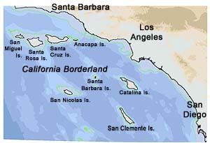
Map courtesy Mike Graham.
©2002-2003 by the Regents of the University of California and the Kavli Institute.
All rights reserved.
Last modifed Friday, June 25, 2003